We woke to pouring rain, and the outlook was for continuing pouring rain all day. Given that we were the only guests at the hut--had we misunderstood when hiking season begins in Switzerland?--we assumed if we fell off a cliff in the rain, it could take until the next weekend for someone to happen upon us. We decided the smartest thing to do would be to hike back down to Brüsti, take the lift down to Attinghaus, and then take buses from there to Engelberg, our destination for the evening.
But first, breakfast! Over the next several days, we learned that one of the joys of hiking in Switzerland is sampling hyperlocal cheeses and homemade butter at breakfast. Every cheese was different. The jam in the glass bowl in the photo below was also homemade. Our host explained that it was Tannengellee, jelly made from fir-tree buds.
After breakfast, we put on our rain pants and rain jackets and backpack rain covers and admired the view from Alp Grat one last time:
Just as we were setting off back down the hill, S shouted, "look! The sun is out! We should hike up to Surenen Pass!"
I remained skeptical, not quite seeing as sunshine what he was seeing as sunshine, and thought we should still head downhill. We started heading down, and at the very first trail intersection, ran into a young couple heading up. S asked if they were heading up to the pass, and they said they were. We figured that meant we could fall off a cliff in the rain and someone would pass by within a day rather than a week. Then another person heading up to the pass passed the four of us, and we decided to head up instead of down.
What a good decision that turned out to be! The hike exceeded all expectations and was one of the most enjoyable of the entire trip. That said, I don't think we were equipped for hiking in a downpour without other people around; had we not encountered anyone else that morning, we would have relied on bus transportation.
Cold rainy weather brings out salamanders. We saw several early on.
Despite S's confidence that the sun was out, we didn't see much at first. Given that we were apparently walking along a ridge with a steep descent on both sides, this was probably helpful for the acrophobe.
We passed a large puddle (too small to call a pond)...
...and some possibly tall ridges with maybe some snow on the side or on top (hard to tell)...
...and had to cross several creeks (mostly easy, and certainly none of which were anywhere near as fast or steep as last year's unexpected snow-melt waterfall crossing).
We appreciated the effort that Switzerland puts into trail blazes...
 |
| We couldn't see where we were going, but we could see which way to go. |
Visibility continued to be limited all the way...
...up to the cold, windy pass.
The steady drizzle promptly turned into rain. We pulled our hoods up, tucked our chins down, and started our descent.
We had heard there was an emergency hut shortly below the pass, and were delighted to see it ahead, and then to step inside to warm up. A pair of underdressed hikers in shorts were warming themselves up with hut-equipped blankets when we arrived.
 |
| We pulled out our fleece jackets and layered up for extra warmth |
 |
| Hut housekeeping poetry for guests passing through |
 |
| Room with a rainy view |
After drying off a bit and fleecing up, we headed back outside, at which moment, unexpectedly, the clouds began to disperse, and we could see glaciers on the mountain Titlis (10,623' elevation) in the distance.
As we started downhill, blue skies peeked through the mists.
Multiple waterfalls flowed down through the meadows...
 |
| Zoom in to see the raindrop clinging to the butterfly's lower antenna |
 |
| Bashful |
Our destination for the evening was Engelberg in the valley below us. We had built a Seilbahn into our descent plans; the Seilbahn station was a few miles out of sight to the right in the photo below.
 |
| Patch of gold-colored rock amidst the granite. Note the waterfall to the right. |
In Usser Äbnet, we passed a cooperative cheese factory and saw our first evidence of the possibility of Grüessäch mitenand, the you-plural greeting of western (vs. eastern) Schwiizerdütsch.
Die Henne über und unter dem Nebelmeer:
It was sometimes a little hard to tell what we were looking at, but whatever it was sure was beautiful.
 |
| Blue skies |
When we reached Fürenalp, the Seilbahn station, I saw my first ever live-in-person Edelweiss. I would see it twice more on this trip, always planted decoratively outside businesses popular with tourists. I've never seen it in the wild.
We warmed up with bowls of cauliflower soup...
...then took the Seilbahn down to Engelsberg. The dense fog made it less anxiety-inducing for me to ride the lift, but the non-acrophobe found it disconcerting. The ride shaved about 2,450' off our descent.
At the bottom of the lift, bright orange plastic spheres were attached to the Seilbahn cables to reduce the chances of airplanes flying into them. The catenary reminded me of the ball arches in Mathemalchemy.
 |
| Catenary |
 |
| Catenary with context |
 |
| Not quite the Restaurant at the End of the Universe... |
We walked from the Talstation to Engelberg. Heavy rain started up again as we neared the Benedictine Monastery, so we ducked inside the church, where musicians were rehearsing for a concert:
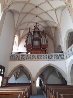
The monastery is home to the largest organ in Switzerland, although the organist was accompanying the rehearsal on an organ at the front of the church.
 |
| Largest organ in Switzerland |
We spent the night at the Engelberg Youth Hostel, which offered friendly service, comfortable accommodations, and a great breakfast for a relatively affordable price in a relatively pricey ski-resort town. S, who had been so enthusiastic about the "sunshine" at the beginning of the day's hike, was concerned about the next day's prospect of constant snow and sleet, so during dinner, we figured out an optional backup plan for the next day, involving buses, trains, and lifts.
Ta da! 11.5 miles, 2,700' ascent, 2,850' descent.
 |
| The straight shot down is the Seilbahn... |


.png)


