Showing posts with label castles. Show all posts

Friday, June 27, 2025

Malerweg Day 4 - Rathen to Altendorf

I returned to Rathen on Wednesday June 4 to hike my last three stages of the Malerweg.

From Rathen, I followed the trail along the Gruenbach...


...through the Amsel Grund, past the Rathewalder Muehle... 

Can you spot the mill?

...and through the small town Rathewald.

Garden flowers in Rathewald

The route eventually led me to the top of the Hockstein, with a narrow valley separating me from the Hohnstein castle one plateau to the east.


I descended to the valley through the Wolfsschlucht ("Wolf's Gorge"), which involved walking into a hole in the rocks and tromping down several hundred steep steps. This slot was one of the highlights of the entire Malerweg.


At last, the end in sight...


If you were to hike in the opposite direction, you'd start by walking into a hole in the rocks on this end too:


It wasn't long before I was heading up to Hohnstein. The castle likely dates to the 13th c., with the first written documentation dating to the first half of the 14th c. 

From 1933-34, the Nazi party used Hohnstein as a concentration camp; from 1935-39, they used it as a youth hostel for the Hitler Jugend; and during WW2, it served as a prison camp.


I didn't know any of that when I explored the town and castle. Nor did I know that the town of Hohnstein had the strongest AfD turnout in all of Germany in the 2025 federal election. The far right party received 57.4% of Hohnstein's votes. 

Tower from the outside...

Tower from the inside...

Tower view: Lilienstein

Getting out of town proved challenging due to a large construction project, but I got back on track and back to stairs and rocks after a generous detour.


Unsurprisingly, the bark beetle has made it to the Saechsische Schweiz. While foresters catch up on slowing the infestation by clearing out dead and dying trees, hikers are advised to watch out for falling branches.


Scourge


I stayed on the Malerweg until it passed through Goßdorf-Kohlmuehle, site of a now-defunct linoleum factory. The factory was purchased for next to nothing in 2016, but toxic waste has prevented renovations

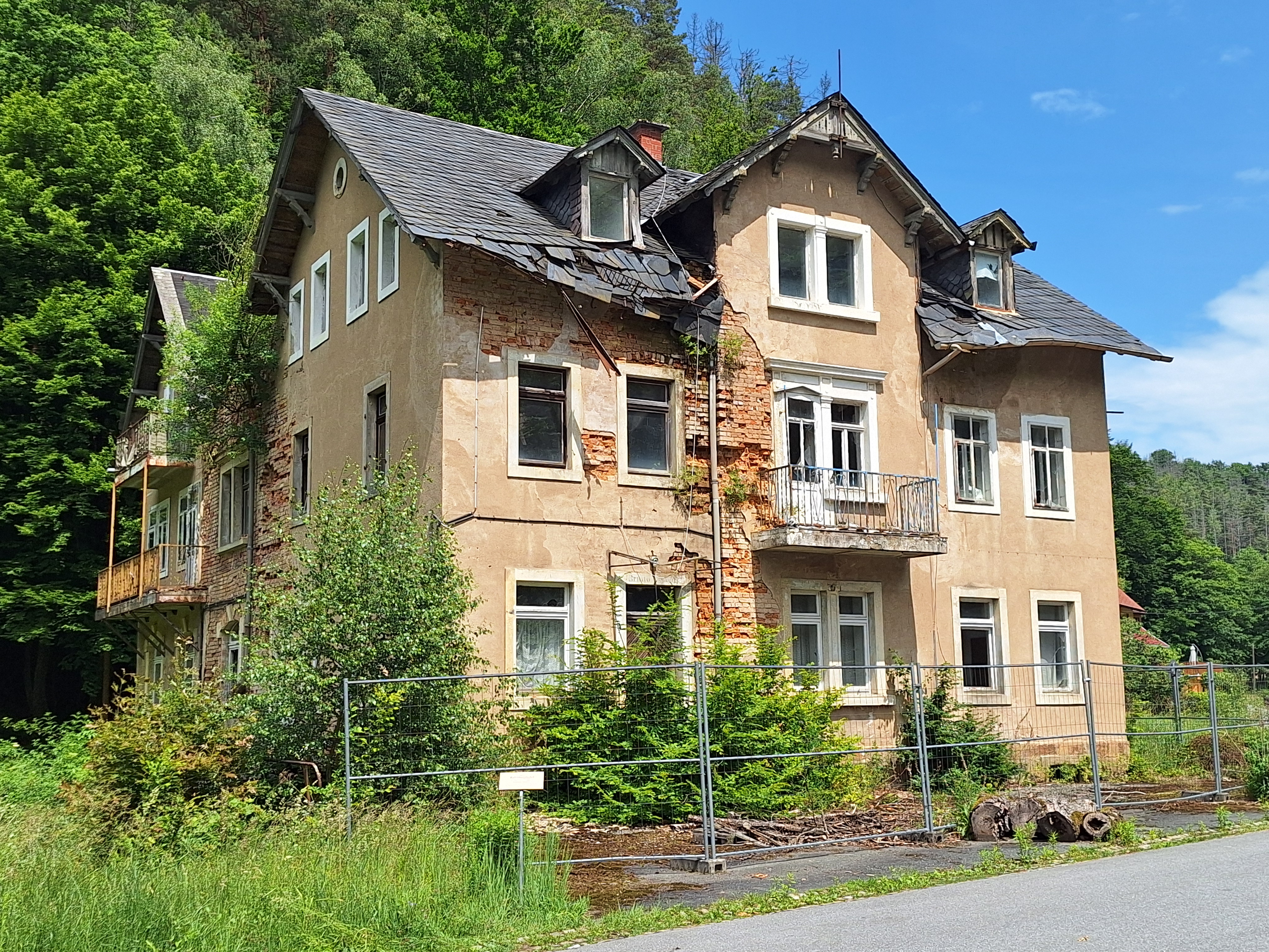
The Bahnhofshotel has seen better days...

...as has the factory.

My accommodation for the night was in Altendorf. Somehow in my route planning, I created a short cut that sent me over a hill instead of around it, chopping off about a mile the Malerweg. Oh well.


Ta da! 13 miles of the day's 18 total

In need of something to do before dinner, I decided to hike the nearby Panoramaweg to the Schlossberg above Bad Schandau.  


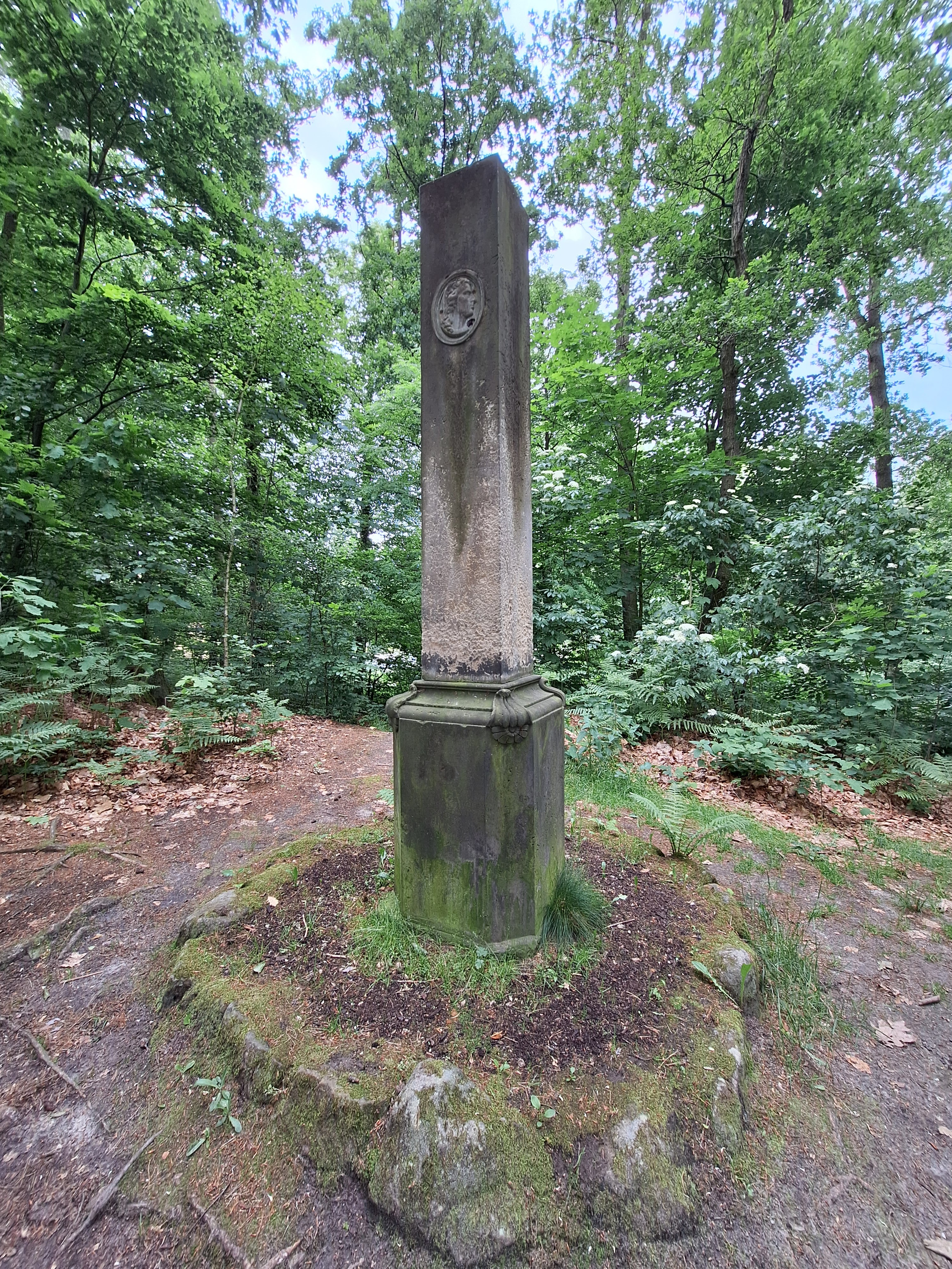
My route took me past a Schiller monument...


...to some fake ruins on the Schlossberg. There are very ruined ruins somewhere on the site--so well ruined that there's nothing left to see--but in the 1880s, fake ruins were added to attract tourists. 


Affenstein--a destination for the following day

Ta da! So close to Bad Schandau, I could have
taken a train back to Dresden for the night

Sunday, August 21, 2022

Maximiliansweg Day 2: Hochrieshuette to SonnenAlm

Day 2: Thursday July 14

The goal of the day was to hike down from Hochries to Aschau, then up Kampenwand to the SonnenAlm. 

Another view from the Hochrieshuette--the field where paragliders launch

Heading down from the hut, we greeted our first cows of the day:


Looking back past the cows up to the hut:


Then it was down down down through the woods...


...with an eventual view of the Chiemsee (which we also saw much of the previous day from Hochries) in the background, with Aschau below the trail:


We learned that the elk in the woods above Aschau speak Boarisch Bairisch Bayrisch Bayerisch and don't like noisy surprises at dawn and dusk:


The town of Aschau presumably grew around the castle on the hill, Hohenaschau, which was first built in the 12th century. We paused in Aschau for lunch, after which Leslie and I parted ways for a few hours. While I hiked up to the SonnenAlm, she visited the castle, then took the gondola lift up. 


I enjoyed more Chiemsee views on the hike up. 


It was a hot day; even the cows were feeling the heat:


There's probably a word for a photo of a selfie-in-progress...


Cows below the SonnenAlm. This is what it means for the hills to be alive with the sound of music...


We ate dinner outside, but inside, the dining room was illuminated by elk antlers:


Ta da! 11 miles.


Thursday, May 5, 2022

Bayern hike photo dump 4: Lechbruck to Zell (Eisenberg)

Monday 4/25

The forecast, again, was for rain all day, but I was learning not to trust the forecasts.

Cloudy, but still clear enough to see the increasingly close Alps:

This lake is named Schmutter Weiher

Off in the distance: a perceptible shaft of sunlight! It is sunny somewhere, just not here. 


I had planned the route to travel along the north side of the Forggensee without realizing I was in for another cliff-side up-and-down hike like I had in the Ammerschlucht. The Forggensee, like the Lechstausee, is a reservoir, which means steep banks and steep drop-offs.


This bench says Nur fuer geimpfte--only for the immunized.


Kinda steep...

As with the Ammerschlucht, the trail eventually spit me out onto green rolling hills, along which I headed to Roßhaupten.


A sticker was slapped onto a road sign along the way, indicating that sometimes in non-English-speaking countries, people use English without really understanding what it means.


I tanked up in Roßhaupten. In theory, Kuchen is a mid-late afternoon ritual, but Roßhaupten was going to be my only big-enough-for-a-bakery town for a while, and the last stop before a steep climb up the Zwieselberg.


Also in Roßhaupten: a 24/7 automated Fleisch dispenser, in case the Metzgerei is closed when you need a hunk of meat. 


From Roßhaupten, I hiked up the Zwieselberg--only about 800 feet up, but enough of an elevation gain to provide excellent views down to the Forggensee.


And look, in the distance--Neuschwanstein, Hohenschwangau, and the Hohes Schloss. This was a great way to see all three castles without having to deal with massive crowds of tourists. Highly recommended.


You can see from the preceding photo that southern Germany is in the middle of a drought--or perhaps the reservoir levels have been lowered in anticipation of coming snow melt. Here's an older photo from the overlook atop Zweiselberg, showing a much fuller Forggensee:


Heading down...


Germany wins the prize for lone-tree-on-a-hill photo ops:


I rounded a curve, and just two hills away--


--were the two ruins I had waffled about visiting this day, because of the supposed rain. As soon as I saw them, they went back onto the day's itinerary, rain or no rain.

Burgruinen Eisenberg is to the left, Burgruinen Hohenfreyberg to the right:


Probably needless to say at this point, but it was a delight to see millions of dandelions carpeting the fields.


You can tell where the electric fences are by where the enclosed livestock have snarfed all the dandelions. They're very thorough.


More dandelions...


Thence followed an ugly, loud stretch of trail that paralleled the freeway for a mile; no photos to offer, and not Komoot's finest moment. But eventually I headed away from the road and skirted around the town of Eisenberg, and the trail signs pointed me toward the ruins.


As I headed into the woods up the hill, evidence suggested that others were enjoying the dandelions too:


If you're going to build a future ruined castle, it's best to situate it on a hilltop, so you can see the marauding invaders from afar. The views were pretty good going up; shortly before I reached Eisenberg, it started raining.


Their Lordships built the castles ca. 1315-40 (Eisenberg) and 1418-32 (Hohenfreyberg). In 1525, during the Peasant Revolt, peasants briefly occupied and trashed the castles. As is generally the case, their Lordships soon got the castles back, and they made the peasants pay out the nose for repairs and expansions. One thus hopes at least some of the descendants of the 1525 peasants were smugly pleased when the Tyrolean government burned the castles down in 1646, toward the end of the 30 Years War, to prevent invading Swedes and French from capturing them. As it turned out, the Swedes and French never made it this far, and the castles didn't need to be torched after all. Oh well.

Here's a view from the Eisenberg ruins down to the town below:


And a view of Hohenfreyberg from Eisenberg:

And Eisenberg itself:


And Eisenberg viewed from Hohenfreyberg. Can one take too many photos of ruins? At this point, my cell phone battery was so close to dead that I couldn't see images of the views I was photographing; I'm consequently pretty pleased with my aim.


I pulled out my spare battery for the hike down to Zell. Zell is so small, and such a common town name, that you're unlikely to find it by Googling unless you include "Eisenberg" in the search. 


Move over, dandelions; it's time for some purple.

My hotel was right next to this church. Note the weathered shingles along the west-facing sides of the building--a style common in this part of the Allgaeu.


Between the distance and the two big hills, this was my most strenuous day so far, and I was looking forward to a delectable dinner at the pension, the website for which touted vegetarian options beyond Spaetzle. Alas, Monday was their Ruhetag (quiet day)--meaning the kitchen was only offering a buffet, only for hotel guests. They suggested I might go to Eisenberg instead--and I might even have walked the extra 4km round trip in the drizzle, except that the interwebs said all of Eisenberg's few restaurants were also closed on Mondays. So the buffet it would be--except that the hotel staff thought the buffet didn't have good enough vegetarian options, and they asked the chef if they could provide some substitutions. I was fully prepared to inhale buffet French fries and salad--reliable vegetarian staples!--but instead I enjoyed a bowl of green-herb cream soup and one of the best gnocchi dishes I've ever had (with grilled vegetables, asparagus, tomatoes, fresh herbs, and some fancy schmancy ornamental foam). Yum.


Ta da! 17.8 miles, 2,539 feet elevation gain.