Friday, August 16, 2024

Lenggries to Brannenburg, Day 5: Bayrischzell to Brannenburg via Wendelstein

Our final day of gap closing took us up the Wendelstein and down to Brannenburg. The Wendelstein is a popular peak for tourists, made easily accessible by gondola from Bayrischzell and cog train from Brannenburg, so we encountered lots of people at the top, but only a few on the trails.

Heading up:


Well would ya look at that: signage for the Koenig Maximilian Weg. Hello, old friend. We had two directions to choose from as we approached the top of the mountain, so of course we took Maximilian's route.


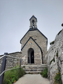
A chapel greeted us near the top...


...with the sort of views we had come to expect:


We paused to enjoy some Kuchen, and then joined many other tourists hiking the Panorama Weg around the top. The route included a tunnel...


...and, as the trail's name suggested, abundant would-be panoramic views:


As we reached the astronomical observatory at the tippy top, the clouds began to clear...


...at least looking up. In every other direction, the views were remarkably similar:

In theory, Hohenpeissenberg is visible yonder...

Posing with a pair of lovers by Erika Maria Lankes


As we headed back down,...

Can you spot the chapel below?

...the clouds finally cleared...

The trail zigged and zagged


...and we could see all the way into the valley below.


We then began the long descent...


...down...


...to...


We didn't take the train, but we waved as it passed by

...Brannenburg. We celebrated with gelato and pizza before hopping on the Regiobahn and S8 back to Steinebach.  


Grand total for our five days' effort: 65 miles, ~16,500 ft elevation gain.

Lenggries to Brannenburg, Day 4: Albert Link Huette to Bayrischzell

It poured the next morning. We waited for a gap in the rain, finally heading out ~9:45 a.m. Given the weather, we decided to hike via Taubenstein rather than the higher Rotwand--a decision also influenced by the indefinite closure of the Rotwandhaus due to bacteria in the water supply.

No rainbows on Sunday...


After hiking up, up, up, we were rewarded with the usual views, which surely were no better up at Rotwand:


S and I hiked a loop from Spitzingsee up to Rotwand in 2022, which included the same section of trail near Taubenstein. When the sun is shining, the views look more like this: 


Oh well. 

At the Taubensteinhaus below the saddle, there was a little excitement. Another hiker let her dog run around off leash in the fields, which ticked off a cow. A chase ensued. The dog circled around straight toward us, the cow in fast pursuit. Thank goodness for narrow turnstiles that let people through fences but keep cows out. The dog owner didn't think any of this was a big deal, but the Alm host was not pleased... 

From the Taubensteinhaus, it was a long, initially steep, descent, with more cloudy views. We took a break for a snack in the woods during a drizzle. Lower down, my cellphone made a long waterfall look ridiculously tiny: 


Once we arrived in the valley, we headed to Osterhofen, just west of Bayrischzell, to our hotel for the night. It was a short day of hiking, with some rain and slippery trails between the Spitzingsee and Taubenstein, but less challenging than the morning's rain and gloomy forecasts had predicted. 

We showered, washed our wet clothes, and then went swimming in our hotel's snazzy pool. Afterward, we walked to Bayrischzell for a noteworthy outdoor dinner in a Gartenrestaurant (Alpenrose) recommended by our hotel's host for its vegetarian options. Some dishes to remember: a honeydew melon gazpacho and a kabob of grilled halloumi and mango.

We caught a bit of alpenglow on the walk back...


Lenggries to Brannenburg, Day 3: Rottach-Egern to Albert Link Huette

I had three different options pre-planned in Komoot for our hike from Rottach-Egern to the Spitzingsee. We settled on one, and were headed out of town when a gentleman spotted us and said, "Stoppp! Are you hiking? Why are you on this ugly busy street instead of the scenic route thattaway that we locals recommend?" So of course, we took the scenic route instead. And while walking on the scenic route, we spied a sign pointing to Bodenschneid, our peak of the day, thisaway, so we decided to be spontaneous, ditched the planned route, and followed the signs instead. 

This fortuitous change meant that we not only passed the Bodenschneidhaus below the peak, but we passed it at just the right time mid-morning to fortify ourselves with tasty Kaiserschmarrn and Schorle while enjoying live music. The musicians were supposed to be at the hut on Sunday, but played on Saturday instead because the forecast for Sunday was for rain all day. Oh dear.

It took a few attempts, but the carefully framed photo below captures many essential aspects of the ideal Bavarian hiking experience: mountains, of course, plus livestock grazing nearby, plus good company, plus Kaiserschmarrn, plus trusty hiking gear, plus live songs auf Bayrisch (that I could understand, no less!), plus beer in cup holders attached to the music stands.


After refueling, we continued up...


...and up...


...and up some more. That's the Tegernsee behind us to the northwest...


...and the Bodenschneidhaus down in the meadow to the north.


A more explicit than usual metal Gipfelkreuz marked the peak...


...while storms brewed above the next mountain to the south.


Since lingering next to a metal lightning rod on the highest hill around listening to thunder seemed like a bad idea, we skedaddled down...


...and down...


...and down some more. We ran into some other hikers who were heading up, who alerted us to a trail closed for forestry work, but they noted that the trail was passable because work was halted for the weekend. So we continued down...


...and down. My camera, as always, failed to capture the steepness of the descent.

Looking down...

At the bottom of the hill was a sign noting the trail closure. There was no sign at the top of the hill. This seems to be the norm of trail-closure signage in Europe. Perhaps if I hiked in the other direction, the signage would have been unhelpfully at the top of the hill instead of the bottom. (This happens to me regularly in Durham too. Maybe signage-too-late-to-be-helpful is my superpower.)


We emerged from the woods to this view...


...then continued down, now on a gravel road rather than wooded trail. Once the road leveled out, the hike past the Spitzingsee to the Albert Link Huette was relatively straightforward.


The hut host's first question for us, upon noting we were from the U.S., was "you have a big election coming up, don't you; are you going to vote? And are you going to vote for the right person?" He had studied abroad in Alabama for a year. We assured him YES and YES.

After a short break in our room, we went outside to the garden for dinner. Our server had lived for a few years in Chicago, a city she loved, and she too noted the world was holding its breath for the upcoming election.

After dinner, we took a backpackless stroll as the skies prepped for Sunday's rain:


Back at the hut, we enjoyed the decor, both manmade...


...and Earth-made. The mountains in the distance are in Austria, where a pot of gold waited to be found.