On Monday, while Elias was off with a friend visiting the highest waterfall in all of Germany (die Todtnauer Wasserfaelle), Stefan and I caught a local train to Gundelfingen, then hiked toward Heuweiler, up to the Zaehringer Burg ruins, and back down into Herdern. En route we ran into none other than Frau L., proprietor of the corner bakery. I hadn't seen her since I almost burst into tears in her store in December--and there she was, picking blackberries in a sunny field next to the trail and enjoying the beautiful day. She handed us some berries and told us enthusiastically about a spot where "you can collect whole pails full!"
Today I stopped by the bakery to pick up some bread for dinner, and Frau L. recognized me from our hiking encounter. Suddenly we were on more than baker-eater terms, and the questions flowed: "how far did you hike, where did you go, how long did it take?" My answers were rewarded with more questions: "where do you live, how long are you here, did you make many acquaintances here in Freiburg?" And then, The Biggie: "oh yes, that's a nice hike indeed, Frau...Frau--Wie heissen Sie?" (How do formal-you call yourself?).
This is a big deal: you're an accepted member of the community when Frau L. begins to address you by your family name.
Wednesday, August 11, 2010
Monday, August 9, 2010
4th Place!
 I forgot to report that Elias's lunch table at camp won "4. Preis fuer Tischmanieren" ("4th-Place Prize for Table Manners"). The teachers said Elias and his friends Johannes, Paul, and Ricarda really deserved first place prizes (which, trust me, is more impressive for what it says about the low standards here than for any active accomplishment), but the rest of the kids brought the table down. To put things in perspective, the total number of lunch tables was five.
Sunday, August 8, 2010
St. Ottilien
Saturday was another lovely, cool, sunny day, so we decided to go hiking again. Because I had gotten a blister coming down the Belchen, we chose something relatively short and easy this time--the Roßkopf-St. Wendelin-St. Ottilien route. We were joined by Jan, a colleague of Stefan's from NCSU who is in Freiburg for a sabbatical.
 Near the end of our hike, we stopped at the restaurant next to St. Ottilien for lunch. The current chapel dates to 1714, but the story of St. Ottilie reaches back to the 7th century: the blind daughter of an Alemannisch count, Ottilie was healed by water flowing from a spring that flows under the chapel site. The chapel is only open occasionally, so it was a special treat for us that folks were setting up for a wedding and we were able to take a quick peek inside.
It didn't occur to me to seek out healing waters for my toe. After lunch, to avoid further blister damage, I contorted my foot and got compensatory blisters on two additional toes. Ouch. When we awoke this morning, Elias cheerfully announced, "Mama, you can be happy--it's raining!"
A packed Friday
On Friday, Stefan and I drove south to Staufen, then east, past Münstertal, and into the hills...
 where we parked and began our hike up the beautiful...
 Belchen (1414m). A helpful trail sign left little doubt about what direction we should take, until we encountered this...
 fork just a dozen meters up the road. Stefan wisely checked the map, but it didn't show the fork, so we stayed to the left until...
 we were strongly advised to go to the right. We had one last view of the...
 valley behind us, where lay nestled the tiny village Kaltwasser, before we headed into the...
 mossy...
 woods. We saw nothing but trees, switchback after switchback, until at long last we emerged...
 atop the ridge, with water vapor still burning off the mountain in the warmth of the late morning sunlight.
The Belchen is clearly a lovely place to spend the summer if you are...
 a sheep or a goat or...
 a cow.
We opted for...
 a more open route back down, and observed that folks on the Belchen enjoy a little more flourish than those on Schauinsland when it comes to...
 stacking wood. After we walked back through...
 Kaltwasser to our rental car, we decided to drive to...
 Staufen for some coffee, seltzer, and ice cream. I believe Germany is one of the only countries in the world where one can make an occasion of going out for seltzer.
We made it back to Freiburg in good time to see...
 the play Elias's summer camp put together. The play is about a king who locks up his daughter because she doesn't want to get married; but then he begins to have regrets and sends a dragon from Toulouse to look after her. First the dragon has to track down the princess; a rabbit is unable to help, and the dragon subsequently receives conflicting directions from two foxes (shown above). Eventually he learns that the princess has been stolen from her tower by a band of robbers; the dragon rescues her and...we have to go back next Friday to see how the story ends, since the play isn't done yet. (Elias won't be in camp next week, so he'll be in the audience rather than on stage.)
Can there be a better way to top off a great day than to go see...
 your two favorite German soccer teams face off in an exhibition game at a small town field in Bahlingen am Kaiserstuhl? How fortuitous that we happened to be in town during the Kaiserstuhl Cup! SC Freiburg beat 1860 Muenchen, 2:0, scoring a dramatic second goal just before the clock ended. Other highpoints of the evening included two storks flying over the field into the setting sun, and the absence of vuvuzelas.
Wednesday, August 4, 2010
Getting around, part II
This morning after Elias left for camp, I walked out the front door and headed south through...
 Herdern, past...
 the Schwabentor bordering the Altstadt, through...
 the Wiehre neighborhood, with all its big snazzy Jugendstil houses, and all the way to...
 the old monastery gate at the edge of the village Guenterstal, where I cut east into the...
 wooded hills. I had five kilometers behind me, and my goal ahead was the top of Freiburg's nearest sizeable mountain, Schauinsland, a mere 8.5 or 9 kilometers further away, depending on whether I believed or followed...
 any of the signs. The signs are quite detailed, as you can see, but they aren't terribly accurate when it comes to distances, and while one trail intersection might have signs pointing you toward 20 different places, another intersection might not have any signs at all. Remember this, remember this, remember this, and do not be lured into false hope by the signs. Instead, carry a good topo map. But don't entirely rely on the map either, since there are always dozens more trails to choose from in real life than will ever fit onto any map, such as the trail less traveled that led me to this...
 mossy bench next to a rivulet. (I'd amuse myself and call it a mossy Bank, since Bank is German for bench, but I'm told puns aren't funny in German, and even a bilingual one is probably a stretch). The trail spit me back out on a gravel road with a bucolic view of...
 sheep. My route threatened to descend back down into Guenterstal, so when I came to a junction, I headed upwards into more...
 woods. There were lots of...


 wildflowers; and of course no hike here would be complete without abundant...
 stinging nettles. The scenery stayed rather...
 consistent for several kilometers, until I gained enough elevation to enjoy a...
 rewarding vista of the valley below. The subsequent views included...
 more woods. Eventually, I passed under...
 the Seilbahn line that runs from the town Horben, in the valley below, up to the top of Schauinsland. The Seilbahn crossing was a welcome sight, because from there on, the trail straightened out somewhat, although it became steeper. I turned onto a mountain-bike path, where I saw a sign warning travelers about...
 horse flies (Bremsen). Oh wait, silly me, the B is lower case: bremsen is a verb: so not "Attention, horse flies," rather "Attention, brake." Further ahead, I crossed the only...
 bridge of the entire hike, and then number 483,000 out of about a bazillion...
 piles of tidily stacked wood. Only...
 2.5 kilometers to go (no, no, don't believe the signs!): past copious, sun-kissed expanses of...

 wildflowers, past...
 the two giant windmills, to a rocky trail that climbed upward, crossed the paved main road, and then terminated at an unmarked T-intersection. No trail sign? Surely that meant either option--left or right--would end up at the top of the mountain. Did I check my map? No, no. I took a left onto a nice wide graded gravel road, because my ultimate goal was the end of the Seilbahn line, and the Seilbahn was now quite a ways to my left. The gravel road continued on and on, passed under the Seilbahn line, and continued on and on some more until it reached...
 a dead end. Realizing I had inadvertently added a few extra kilometers to my hike, I cursed loudly (in English, because I haven't lived in Germany long enough to instinctively curse in German) before cutting down to the...
 paved road. After walking a short while, I saw a...
 Naturschutzgebiet (nature preserve) trail that wasn't on the map. It offered a significant shortcut, as well as some...
 fine views, before meeting up again with the paved road, which I followed the rest of the way to my...
 final destination, where...
 this handsome guy was waiting for me. The grand total: five hours, 23.3 kilometers (significantly more than 5 + 9, you might observe), and one kilometer elevation gain. (Stefan, for his part, biked 69 kilometers round trip in a little over three hours, climbing a combined total of about 1440 meters: Freiburg-Zaehringen-Heuweiler-St. Peter [break for a hazelnut pastry]-Unterriebental-Kirchzarten-Oberried-Hofsgrund-Schauinsland-Freiburg.)
After half a liter of Sprudel (seltzer), a Heidelbeershake (you'd think that would translate as blueberry milkshake, but it's actually a foamy lukewarm puree of blueberries and milk), and a plate of Pommes (fries)--a nutritious vegetarian lunch if there ever was one--I took the fast way home:


 Herdern, past...
 the Schwabentor bordering the Altstadt, through...
 the Wiehre neighborhood, with all its big snazzy Jugendstil houses, and all the way to...
 the old monastery gate at the edge of the village Guenterstal, where I cut east into the...
 wooded hills. I had five kilometers behind me, and my goal ahead was the top of Freiburg's nearest sizeable mountain, Schauinsland, a mere 8.5 or 9 kilometers further away, depending on whether I believed or followed...
 any of the signs. The signs are quite detailed, as you can see, but they aren't terribly accurate when it comes to distances, and while one trail intersection might have signs pointing you toward 20 different places, another intersection might not have any signs at all. Remember this, remember this, remember this, and do not be lured into false hope by the signs. Instead, carry a good topo map. But don't entirely rely on the map either, since there are always dozens more trails to choose from in real life than will ever fit onto any map, such as the trail less traveled that led me to this...
 mossy bench next to a rivulet. (I'd amuse myself and call it a mossy Bank, since Bank is German for bench, but I'm told puns aren't funny in German, and even a bilingual one is probably a stretch). The trail spit me back out on a gravel road with a bucolic view of...
 sheep. My route threatened to descend back down into Guenterstal, so when I came to a junction, I headed upwards into more...
 woods. There were lots of...


 wildflowers; and of course no hike here would be complete without abundant...
 stinging nettles. The scenery stayed rather...
 consistent for several kilometers, until I gained enough elevation to enjoy a...
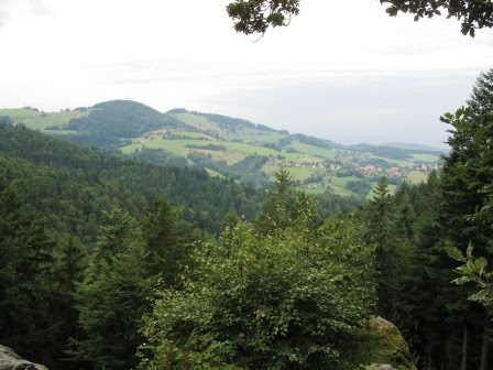 rewarding vista of the valley below. The subsequent views included...
 more woods. Eventually, I passed under...
 the Seilbahn line that runs from the town Horben, in the valley below, up to the top of Schauinsland. The Seilbahn crossing was a welcome sight, because from there on, the trail straightened out somewhat, although it became steeper. I turned onto a mountain-bike path, where I saw a sign warning travelers about...
 horse flies (Bremsen). Oh wait, silly me, the B is lower case: bremsen is a verb: so not "Attention, horse flies," rather "Attention, brake." Further ahead, I crossed the only...
 bridge of the entire hike, and then number 483,000 out of about a bazillion...
 piles of tidily stacked wood. Only...
 2.5 kilometers to go (no, no, don't believe the signs!): past copious, sun-kissed expanses of...
 wildflowers, past...
 the two giant windmills, to a rocky trail that climbed upward, crossed the paved main road, and then terminated at an unmarked T-intersection. No trail sign? Surely that meant either option--left or right--would end up at the top of the mountain. Did I check my map? No, no. I took a left onto a nice wide graded gravel road, because my ultimate goal was the end of the Seilbahn line, and the Seilbahn was now quite a ways to my left. The gravel road continued on and on, passed under the Seilbahn line, and continued on and on some more until it reached...
 a dead end. Realizing I had inadvertently added a few extra kilometers to my hike, I cursed loudly (in English, because I haven't lived in Germany long enough to instinctively curse in German) before cutting down to the...
 paved road. After walking a short while, I saw a...
 Naturschutzgebiet (nature preserve) trail that wasn't on the map. It offered a significant shortcut, as well as some...
 fine views, before meeting up again with the paved road, which I followed the rest of the way to my...
 final destination, where...
 this handsome guy was waiting for me. The grand total: five hours, 23.3 kilometers (significantly more than 5 + 9, you might observe), and one kilometer elevation gain. (Stefan, for his part, biked 69 kilometers round trip in a little over three hours, climbing a combined total of about 1440 meters: Freiburg-Zaehringen-Heuweiler-St. Peter [break for a hazelnut pastry]-Unterriebental-Kirchzarten-Oberried-Hofsgrund-Schauinsland-Freiburg.)
After half a liter of Sprudel (seltzer), a Heidelbeershake (you'd think that would translate as blueberry milkshake, but it's actually a foamy lukewarm puree of blueberries and milk), and a plate of Pommes (fries)--a nutritious vegetarian lunch if there ever was one--I took the fast way home:


Subscribe to:
Posts (Atom)
